Plain
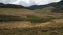
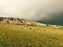
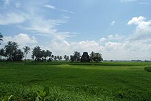
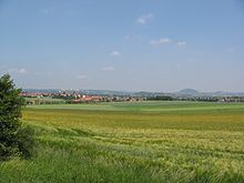
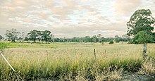
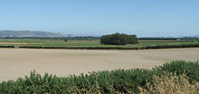
In geography, a plain is a flat expanse of land that generally does not change much in elevation, and is primarily treeless. Plains occur as lowlands along valleys or at the base of mountains, as coastal plains, and as plateaus or uplands.[1]
In a valley, a plain is enclosed on two sides, but in other cases a plain may be delineated by a complete or partial ring of hills, by mountains, or by cliffs. Where a geological region contains more than one plain, they may be connected by a pass (sometimes termed a gap). Coastal plains mostly rise from sea level until they run into elevated features such as mountains or plateaus.[2]
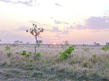
Plains are one of the major landforms on earth, where they are present on all continents, and cover more than one-third of the world's land area.[3] Plains can be formed from flowing lava; from deposition of sediment by water, ice, or wind; or formed by erosion by the agents from hills and mountains. Biomes on plains include grassland (temperate or subtropical), steppe (semi-arid), savannah (tropical) or tundra (polar). In a few instances, deserts and rainforests may also be considered plains.[4]
Plains in many areas are important for agriculture because where the soils were deposited as sediments they may be deep and fertile, and the flatness facilitates mechanization of crop production; or because they support grasslands which provide good grazing for livestock.[5]
Types of plain

Depositional plains
The types of depositional plains include:
- Abyssal plains, flat or very gently sloping areas of the deep ocean basin.[6][7]
- Planitia/pləˈnɪʃiə/ , the Latin word for plain, is used in the naming of plains on extraterrestrial objects (planets and moons), such as Hellas Planitia on Mars or Sedna Planitia on Venus.
- Alluvial plains, which are formed by rivers and which may be one of these overlapping types:
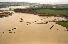
- Alluvial plains, formed over a long period of time by a river depositing sediment on their flood plains or beds, which become alluvial soil. The difference between a flood plain and an alluvial plain is: a flood plain represents areas experiencing flooding fairly regularly in the present or recently, whereas an alluvial plain includes areas where a flood plain is now and used to be, or areas which only experience flooding a few times a century.[8]
- Flood plain, adjacent to a lake, river, stream, or wetland that experiences occasional or periodic flooding.
- Scroll plain, a plain through which a river meanders with a very low gradient.
- Glacial plains, formed by the movement of glaciers under the force of gravity:
- Outwash plain (also known as sandur; plural sandar), a glacial out-wash plain formed of sediments deposited by melt-water at the terminus of a glacier. Sandar consist mainly of stratified (layered and sorted) gravel and sand.[9][10]
- Till plains, plain of glacial till that form when a sheet of ice becomes detached from the main body of a glacier and melts in place depositing the sediments it carries. Till plains are composed of unsorted material (till) of all sizes.
- Lacustrine plains, plains that originally formed in a lacustrine environment, that is, as the bed of a lake.[11]
- Lava plains, formed by sheets of flowing lava.[12]
Erosional plains
Erosional plains have been leveled by various agents of denudation such as running water, rivers, wind and glacier which wear out the rugged surface and smoothens them. Plain resulting from the action of these agents of denudation are called peneplains (almost plain) while plains formed from wind action are called pediplains.[13]
Structural plains
Structural plains are relatively undisturbed horizontal surfaces of the Earth. They are structurally depressed areas of the world that make up some of the most extensive natural lowlands on the Earth's surface.[14]


Notable examples


Americas
- Altiplano (Bolivia, Chile)
- Altiplano Cundiboyacense (Colombia)
- Caroni Plain (Trinidad and Tobago)
- Chilean Central Valley
- Gran Chaco (Argentina, Bolivia, Paraguay)
- Llanos (Colombia and Venezuela)
- Pampas (Argentina, Uruguay, Brazil)
- Coastal plains of Chile
- Atlantic coastal plain (United States)
- Carrizo Plain (California, United States)
- Great Plains (Canada and United States)
- Gulf Coastal Plain (Mexico and United States)
- Interior Plains (Canada and United States)
- Lake Superior Lowland (Wisconsin, United States)
- Laramie Plains (Wyoming)
- Mississippi Alluvial Plain (Mississippi)
- Oxnard Plain (Ventura County, California)
- Snake River Plain (Idaho)
Asia
- Chianan Plain (Taiwan)
- Depsang Plains (China and India)
- Honam Plain (South Korea)
- Kantō Plain (Japan)
- Kedu Plain (Indonesia)
- Kewu Plain (Indonesia)
- Mallig Plains (Philippines)
- Nōbi Plain (Japan)
- North China Plain (China)
- Osaka Plain (Japan)
- Pingtung Plain (Taiwan)
- Sarobetsu plain (Japan)
- Yilan Plain (Taiwan)
- Bhuikhel (Nepal)
- Depsang Plains (India and China)
- Dooars (India and Bhutan)
- Eastern coastal plains (India)
- Indo-Gangetic Plains (Bangladesh, India, Nepal and Pakistan)
- More plains (India)
- North Bengal plains (Bangladesh and India)
- Punjab Plains (Pakistan and India)
- Terai (India and Nepal)
- Utkal Plains (India)
- Western coastal plains (India)
- Al-Ghab Plain (Syria)
- Aleppo plateau (Syria)
- Ararat plain (Armenia and Turkey)
- Israeli coastal plain (Israel)
- Khuzestan Plain (Iran)
- Mugan plain (Azerbaijan and Iran)
- Nineveh Plains (Iraqi Kurdistan)
- Shiraki Plain (Georgia)
Europe
- Limagne (France)
- North German Plain
- Ochsenfeld (France)
- Pannonian Basin (Central Europe)
- Parndorf Plain (Austria)
- Westphalian Lowland (Germany)
- Bărăgan Plain (Romania)
- Danubian Plain (Bulgaria)
- Dnieper Lowland (Ukraine)
- East European Plain
- European Plain
- Great Hungarian Plain
- Kosovo field (Kosovo)
- Little Hungarian Plain (Austria, Hungary, and Slovakia)
- Pannonian Steppe (Hungary)
- Polesian Lowland (Ukraine and Belarus)
- Upper Thracian Plain (Bulgaria)
- Wallachian Plain (Romania)
- Cheshire Plain (England)
- Hardangervidda (Norway)
- Kaffiøyra (Svalbard, Norway)
- Muddus plains (Sweden)
- North European Plain
- North Northumberland Coastal Plain (Northern England)
- North Somerset Levels (North Somerset, England)
- Salisbury Plain (England)
- Solway Plain (Cumbria, England)
- Somerset Levels (Somerset, England)
- South Coast Plain (Hampshire and Sussex, England)
- South Småland peneplain (Sweden)
- Stora Alvaret (Öland, Sweden)
- Strandflat (Norway)
- Sub-Cambrian peneplain (Nordic countries)
- The Fylde (Lancashire, England)
- Agro Nocerino Sarnese (Italy)
- Campidano (Italy)
- Lelantine Plain (Greece)
- Mesaoria (Cyprus)
- Messara Plain (Greece)
- Nurra (Sardinia, Italy)
- Po Valley (Italy)
- Rieti Valley (Central Italy)
- Tavoliere delle Puglie (Southern Italy)
Oceania
- Bogong High Plains (Victorian Alps, Australia)
- Cumberland Plain (Sydney, Australia)
- Esperance Plains (Western Australia)
- Molonglo Plain (Australian Capital Territory)
- Mulga Lands (eastern Australia)
- Nullarbor Plain (Southern Australia)
- Ord Victoria Plain (Northern Australia)
- Swan Coastal Plain (Perth, Australia)
- Awarua Plains (Southland)
- Canterbury Plains (Canterbury)
- Hauraki Plains (Waikato)
- Maniototo (Otago)
- Taieri (Otago)
See also
- Field – Area of land used for agricultural purposes
- Flooded grasslands and savannas
- Flood-meadow
- Machair – Fertile low-lying grassy plain
- Meadow – Open habitat vegetated primarily by non-woody plants
- Pasture – Land used for grazing
- Prairie – Ecosystems considered part of the temperate grasslands, savannas, and shrublands biome
- Rangeland – Biomes which can be grazed by animals or livestock (grasslands, woodlands, prairies, etc)
- Water-meadow
- Wet meadow
References
- Rood, Stewart B.; Pan, Jason; Gill, Karen M.; Franks, Carmen G.; Samuelson, Glenda M.; Shepherd, Anita (2008-02-01). "Declining summer flows of Rocky Mountain rivers: Changing seasonal hydrology and probable impacts on floodplain forests". Journal of Hydrology. 349 (3–4): 397–410. Bibcode:2008JHyd..349..397R. doi:10.1016/j.jhydrol.2007.11.012.
- Whittow, John (1984). Dictionary of Physical Geography. London: Penguin. p. 467. ISBN978-0-14-051094-2 .
- Geoff C. Brown; C. J. Hawkesworth; R. C. L. Wilson (1992). Understanding the Earth (2nd ed.). Cambridge University Press. p. 93. ISBN978-0-521-42740-1 . Archived from the original on 2016-06-03.
- Gornitz, Vivien, ed. (2009). Encyclopedia of Paleoclimatology And Ancient Environments. Dordrecht: Springer. p. 665. ISBN9781402045516 .
- Powell, W. Gabe. 2009. Identifying Land Use/Land Cover (LULC) Using National Agriculture Imagery Program (NAIP) Data as a Hydrologic Model Input for Local Flood Plain Management. Applied Research Project, Texas State University.
- Goudie, A. S., ed. (2004). "Denudation chronology". Encyclopedia of Geomorphology. pp. 244–248.
- Vinogradova, N.G. (1997). "Zoogeography of the Abyssal and Hadal Zones". The Biogeography of the Oceans. Advances in Marine Biology. 32. pp. 325–387. doi:10.1016/S0065-2881(08)60019-X. ISBN9780120261321 .
- "Glossary of Landform and Geologic Terms"(PDF) . National Soil Survey Handbook—Part 629. National Cooperative Soil Survey. April 2013. Archived from the original on 22 October 2016. Retrieved 17 August 2016.
- Magilligan F.J., Gomez B., Mertes L.A.K., Smith, L.C. Smith N.D., Finnegan D., Garvin J.B., Geomorphic effectiveness, sandur development, and the pattern of landscape response during jökulhlaups: Skeiðarársandur, southeastern Iceland, Geomorphology 44 (2002) 95–113
- Smith L.C., Sheng Y., Magilligan F.J., Smith N.D., Gomez B., Mertes L., Krabill W.B., Garven J.B., Geomorphic impact and rapid subsequent recovery from the 1996 Skeiðarársandur jökulhlaup, Iceland, measured with multi-year airborne lidar. Geomorphology vol. 75 Is. 1–2 (2006) 65–75
- "Archived copy"(PDF) . Archived(PDF) from the original on 2016-03-03. Retrieved 2015-12-16.
- "Lava Plateaus". Archived from the original on 2013-11-14. Retrieved 2014-01-26.
- Migoń, Piotr (2004). "Planation surface". In Goudie, A.S. (ed.). Encyclopedia of Geomorphology. pp. 788–792.
- "Pediplain". Encyclopedia Britannica.
External links
- Media related to Plains at Wikimedia Commons